Martins of Rushestown
The Family of John martin and bridget ward
The Land: Rushestown
John and Bridget Ward Martin lived in the townland of Rushestown, in the civil parish of Killian, district (aka union) of Mountbellew, County Galway, Ireland. My best guess is that John lived in Ward's Village (see listings below).
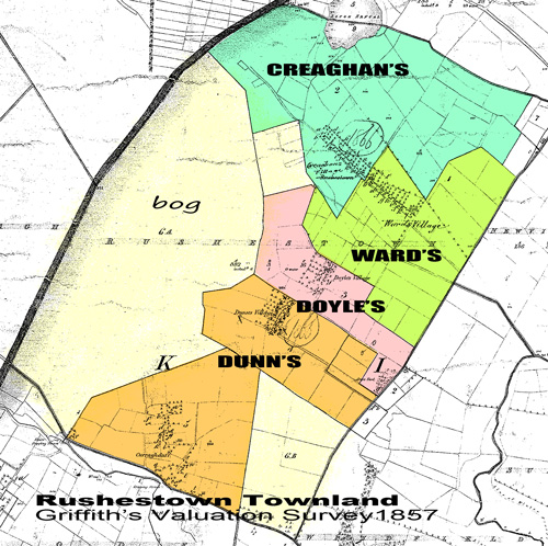
Griffith's Valuation Survey. The best source of information about the land in mid-19th century Ireland is Griffith's Valuation [2], a survey of every parcel of land for the purpose of taxation. After extensive surveying, the master maps were produced about 1840. The valuations for Galway land and its occupiers was issued on 29 June 1857 (although you can see notations of "1866" on the "version 3" map below [2]).

Rushestown of 1857 (we'll say) was divided into 6 parcels and the tenants paid their rent to John N. Gerrard. I colored the map above according to my best interpretation of the data. Five parcels were operated communally by groups of farmers, in the old rundale system [4].
Parcel 1. Ward's Village. 14 rent-payers in 13 houses with various out-buildings at the eastern end of Rushestown village. The "occupiers" (rent-payers, not necessarily heads-of-household): Patrick Concannon, Mary Crehan, Catherine Mulligan, James Kenny, Michael Kenny, Edmond Donnelly, Matthias Grehan, Thomas Crehan, Marcus Ward, John Martin, Peter Martin, Catherine Ward, Bryan Ward, and Patrick Creaghan (land only). Acreage: 192.
Parcel 2. Creaghan's Village. 16 occupiers in 15 houses with various out-buildings at the western end of Rushestown village. Occupiers: Owen Creaghan, Owen Creaghan (a second house), John Dunne, Michl. Cunningham, Laur. Cunningham, Patrick Tully, Bryan Cunningham, Martin Crehan (outbuildings, land only), Michl "Owen"* Cunningham, Patrick Crehan, Michl "Bryan"* Cunningham, Michael White, Michl. "Nelly"* Cunningham, John Crehan, Patrick Creaghan. Acreage: 120.
Parcel 3. Doyle's Village. 8 occupiers in 7 houses, with outbuildings. Dominick Doyle, Marcus Crehan, Patk. Cunningham, Cath. Cunningham, Patrick Doyl, Bryan Crehan, Bryan Manion (land only), Mary Feeney (paid house rent to Bryan Manion). Acreage: 47.
Parcel 4. Dunn's Village. 10 occupiers in 7 houses, with out-building. Occupiers: Michael Martin, Michael Crehan, John Crehan (land only), Margaret Dunne, Marcus Crehan (land only), Peter Lohan, Mary Conry, Michael Crehan (land only), John Crehan, Peter Crehan. Acreage: 72.
Parcel 5. Dunn's Village/Curraghduff. Village clustered at the south end of Rushestown, apparently part of Dunn's. 21 occupiers in 21 houses and outbuildings. Occupiers: Patrick Collins, Patrick Feeny, Patrick Connaghtin, John Connaghtin, Thomas Connaghtin, Peter Feeney, Matthias Faraher, Denis Morrissy, Thomas Hughes, Peter Morrissy, Edmund Donnellan, Thomas Manion, Patrick Donnellan, Thoms Lyons, John Donnellan, Michael Hughes. Acreage: 98. Not in the rundale: Alice Dempsey (sublet house from Denis Morrissy), Michael Manion (sublet house from Peter Morrissy), Michael Feeny, John Feeny (operated the forge), Patrick Ruanne (sublet from Thomas Manion).
Updated 10.30.09
NOTES
[1] Source: James R Reilly CGRS. "Is There More in Griffith's Valuation Than Just Names?" online
[2] Source: from Origins Network
[3] Griffith's Valuation, Delia Publications online
[4] Rundale system: landholders were communally responsible for paying the rent to the landlord.
*Duplicate names were given arbitrary "agnomens" to distinguish them.
